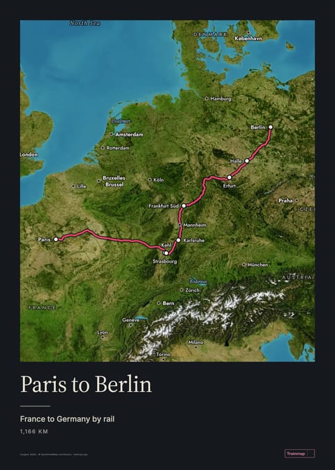
The direct ICE from Paris to Berlin takes about 7 h 46 min and is run jointly by Deutsche Bahn and SNCF. It is the first direct ICE between the two capitals. It started in December 2024 and has run via Erfurt and Halle since December 2025. Nearly a quarter of a million passengers took it in its first year. Since March 2026 the private European Sleeper has also run a direct night train.
On your wallParis to Berlin on the Satellite map, as a 50 × 70 cm poster. The style, size and words are yours to change.
Route facts
Duration (day)
≈ 7 h 46 direct ICE, one daily each way (Berlin dep 07:06, Paris dep 11:07)1
Duration (night)
≈ 16 h, European Sleeper via Brussels, 3 nights/week since 26 March 20262
Distance
1,166 km along the line on this map (878 km in a straight line)
Operators
DB + SNCF (ICE 3, up to 320 km/h on the LGV Est); European Sleeper (night)3
The height of the track, from AWS Open Data terrain tiles along
Trainmap's route. Through tunnels and over bridges, which come from OpenStreetMap,
the line runs straight from one end to the other. The highest station is Erfurt Hbf,
at 199 m.
Scenic highlights
LGV Est plains. Across eastern France the train runs at about 310 km/h, too fast to take in much of the view.5
After the Rhine at Kehl. After the Rhine at Kehl the line runs through forest, meadows and wine villages. Reviewers call it the most beautiful part of the trip.5
Stations on this route
Paris Gare de l’Est
Strasbourg
Kehl
Karlsruhe Hbf
Frankfurt (Main) Süd
Erfurt Hbf
Halle (Saale) Hbf
Berlin Hbf
After nine years with no direct train, the ÖBB Nightjet returned in December 2023 and the direct ICE followed in December 2024. The Nightjet was withdrawn again in December 2025 when French public funding ended, and the private European Sleeper took over the night service in March 2026 (Railway Pro, Seat 61).
“The good German-French cooperation is the backbone of a united Europe. The new ICE direct connection between Berlin and Paris is a symbol of this.”
Richard Lutz, CEO of Deutsche Bahn, 16 December 20244
Place namesAs they are written there, or in English
3D terrainTilt the map to see it
CameraStay put, or ride along as a route draws
LinesWhich lines new routes can use. All also lists junctions, depots and closed stations in search
How to make a train map
Free · real tracks
Trainmap is a free train map maker. Pick the stations you travelled between and it draws the journey along the real railway, not as a straight line, on a map you can name, style and share.
Making one
Add a route. Choose the station you set off from and the one you arrived at. Add stops in between if your train went a particular way.
Add the others. Each journey gets its own colour: a trip across Europe, a daily commute, every leg of an Interrail trip, on one map.
Choose a look and share it. There are a dozen styles, from a clean modern map to 1920s railway posters, satellite and a night view. Your map’s link opens it for anyone.
Already logging your trips?
If you keep a log in Trainlog or Träwelling, or Google Maps has your Timeline, import it. The file is read in your browser and your journeys appear together on one map.
Questions
Is Trainmap free?
Yes. Making, saving and sharing maps costs nothing, and you don’t need an account. An account keeps your maps on all your devices.
Which countries does it cover?
Europe, from Portugal to Finland and from Ireland to Turkey. The lines follow the railway as it is mapped in OpenStreetMap.
Can I print my map?
You can design a poster of it now. Printed posters aren’t on sale yet: reserve one and we’ll email you once they are.
Does it work on a phone?
Yes, in the browser. There’s nothing to install.
Not sure where to start? The iconic routes, from the Glacier Express to the Orient Express, are drawn and ready to open.