Glacier Express Route
Glacier Express Route
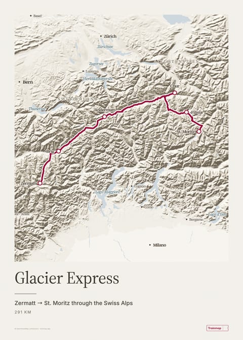
Zermatt → St. Moritz through the Swiss Alps
Routes on this map
The Glacier Express runs between Zermatt and St. Moritz in about 8 hours, covering 291 km of Swiss mountain railway with 291 bridges and 91 tunnels on the way. The Rhaetian Railway and the Matterhorn Gotthard Bahn run it together and sell it as the world's slowest express train. The map below follows the track it actually takes.
Route facts
| Duration | ≈ 8 hours end to end1 |
|---|---|
| Distance | 291 km, with 291 bridges and 91 tunnels2 |
| Highest point | Oberalp Pass, 2,033 m (lowest: Chur, 585 m)1 |
| Operator | Rhaetian Railway (RhB) + Matterhorn Gotthard Bahn, as Glacier Express AG3 |
| Reservations | Obligatory for all passengers; open 93 days ahead4 |
| Fares (2026) | Zermatt–St. Moritz CHF 159 (2nd) / CHF 272 (1st) + CHF 54 seat reservation; Excellence Class surcharge CHF 540. Book at glacierexpress.ch5 |
| Season | Runs winter and summer; annual break mid-Oct to early Dec (2026: no trains 11 Oct–4 Dec)6 |
| Runs since | 25 June 19307 |
Height along the route
Scenic highlights
- Landwasser Viaduct. The most photographed spot on the Rhaetian Railway, shortly before Filisur. The curved stone viaduct is 142 m long and 65 m high, and it runs straight into a tunnel cut in a vertical rock face. Side to sit: right travelling Zermatt → St. Moritz (official operator guidance).1
- Rhine Gorge (Ruinaulta). Between Reichenau and Ilanz the line follows the Rhine through the gorge known as the Swiss Grand Canyon, which the river cut through the debris of the Flims rockslide about 10,000 years ago.8
- Oberalp Pass. The highest point of the line, at 2,033 m. Lake Toma, counted as the source of the Rhine, lies just above the pass.1
- Albula Line. Between Preda and Bergün the line uses six viaducts and five spiral or helical tunnels to climb 400 m. This stretch is part of the UNESCO World Heritage railway.1
- Matter Valley. The first 25 km from Zermatt run past the highest vineyards in Europe, below 29 peaks over 4,000 m, starting with the 4,478 m Matterhorn.1
Stations on this route
- Zermatt
- Brig
- Andermatt
- Chur
- Filisur
- St. Moritz Bahnhof
The steepest stretch climbs at 125‰, and 31.9 km of the line has a cogwheel rack. The 15.4 km Furka tunnel, the longest on the route, opened in 1982 and let the train run in winter. The Albula and Bernina lines the train uses have been a UNESCO World Heritage Site (Rhaetian Railway in the Albula/Bernina Landscapes) since 2008.
“The world's slowest express train”
Switzerland Tourism9
Related routes
Sources
- glacierexpress.ch
- glacierexpress.ch
- en.wikipedia.org
- glacierexpress.ch
- glacierexpress.ch
- glacierexpress.ch
- glacierexpress.ch
- glacierexpress.ch
- myswitzerland.com
Facts last checked 18 July 2026 · About Trainmap · All iconic routes
Map style
Everyday
Elevation
Classic
From space

Built by Arinbjörn, sometimes on a train · About
About & credits
Rail data: OpenStreetMap contributors (ODbL)
Stations: Trainline, Nominatim
Maps: OpenStreetMap contributors via Protomaps, self-hosted
Terrain: EU-DEM (Copernicus), USGS, NOAA et al.
Powered by MapLibre GL JS