Bergen Line Route
Bergen Line Route
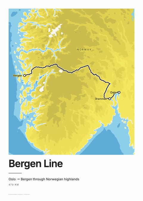
Oslo → Bergen through Norwegian highlands
Routes on this map
The Bergen Line (Bergensbanen) runs between Oslo and Bergen in about 7 hours, across the Hardangervidda, the largest high mountain plateau in Northern Europe. Vy operates it. It is the highest main line in Northern Europe, reaching 1,237 m inside the Finse Tunnel, and roughly 100 km of it lies above the tree line.
Route facts
| Duration | ≈ 7 h (fastest ≈ 6.5 h); five departures daily, four in winter1 |
|---|---|
| Distance | ≈ 496 km Oslo–Bergen, with about 180 tunnels2 |
| Highest point | 1,237 m in the Finse Tunnel; Finse station at 1,222 m is the line's highest2 |
| Operator | Vy (trains); Bane NOR (infrastructure)2 |
| Reservations | Compulsory seat reservation; passholders ≈ NOK 1003 |
| Fares (2026) | Advance fares from under NOK 300 one-way (dynamic pricing). Book at vy.no4 |
| Best time | All year; in late May and early June the valleys are green and the plateau still has snow4 |
| Opened | 27 November 1909, by King Haakon VII at Voss5 |
Height along the route
Scenic highlights
- Hardangervidda crossing. The longest stretch above the tree line, across Northern Europe's largest mountain plateau, with views to the Hardangerjøkulen glacier. Side to sit: left travelling from Oslo (Norway Insider).1
- Finse. The highest station on the line, at 1,222 m. The ice fields around it stood in for the planet Hoth in Star Wars.4
- Myrdal. The junction for the 20.4 km Flåm Railway, which drops to the Aurlandsfjord.1
- Raundalen descent. West of Myrdal the line drops through a valley of cliffs and waterfalls, and the fjords come into view on the way to Bergen.4
All stops on the Bergen Line
Every station the daytime trains between Oslo S and Bergen call at, in order, from Vy's timetable for autumn and winter 2026 (open data from Entur). Many trains skip some of the smaller stations.
- Oslo S
- Sandvika
- Asker
- Drammen
- Hokksund
- Vikersund
- Hønefoss
- Flå
- Nesbyen
- Gol
- Ål
- Geilo
- Ustaoset
- Haugastøl
- Finse the highest station, 1,222 m
- Hallingskeid
- Myrdal
- Voss
- Dale
- Arna
- Bergen
More than 15,000 men built the line, mostly by hand, over 15 years. It cost as much as a whole Norwegian state budget of the time, according to the Norwegian Royal House. For the centenary in 2009 the broadcaster NRK showed the entire 7-hour trip minute by minute; 1.2 million Norwegians watched, and the format became known as slow TV.
“Dette er vårt slektsledds storverk (this is our generation's great work).”
King Haakon VII, opening the line, 27 November 19095
Related routes
Sources
Facts last checked 18 July 2026 · About Trainmap · All iconic routes
Map style
Everyday
Elevation
Classic
From space


Built by Arinbjörn, sometimes on a train · About
About & credits
Rail data: OpenStreetMap contributors (ODbL)
Stations: Trainline, Nominatim
Maps: OpenStreetMap contributors via Protomaps, self-hosted
Terrain: EU-DEM (Copernicus), USGS, NOAA et al.
Powered by MapLibre GL JS